|
REMEDIAL INVESTIGATION
Soil and groundwater contamination may result from numerous sources. In
most cases, the source(s) is related to historic operations such as retail
fueling, industry or manufacturing, landfills, mines, and even agriculture
at the site, or, in some cases, the source(s) may have been associated
with prior land use on potentially one more neighboring properties. ART
provides services for investigation, and, if necessary, remediation of
soil and groundwater contamination. The key to developing an effective
remediation program is to understand the nature and extent of contaminants
in the subsurface. ART uses an array of costeffective investigation
methods to fully understand the geology, hydrogeology, contaminant distribution,
and contaminant fate and transport. The following summarizes select investigation
methods commonly used by ART in conducting remedial investigations:
Phase One investigations are conducted
to evaluate property that has not previously been investigated. These
investigations are typically non-intrusive and include site visits, review
of regulatory agencies file records of the site and neighboring properties,
and review of aerial photographs to evaluate potential historic use of
the Site and surrounding area Phase Two investigations consist of the
follow-up evaluations for information collected during the Phase One.
Phase Two includes air, soil and groundwater
sampling and analysis, drilling and installation of groundwater monitoring
wells, and preparation of a report that summarizes and discusses the environmental
impact of the sampling and analysis results, and provides recommendations
for additional work.
Geologic
Assessments are conducted to understand the site geology and develop
a site conceptual model. This includes the following - review of aerial
photographs to evaluate surface features such as potential faults; field
geologic mapping to determine rock/soil types and potential geologic features
such as fractures and faults; logging of soil collected from borings to
evaluate subsurface lithology; and, geophysical surveys to evaluate subsurface
geologic structures, depth to bedrock, geologic contacts, faulting, and
even differing groundwater chemistry.
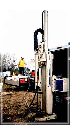 Hydrogeologic
Assessments are conducted to develop a site conceptual model and obtain
a comprehensive understanding of groundwater flow direction and gradient,
nearby surface water features, local groundwater use such as nearby pumping
wells, and recharge zones. These are performed by installing piezometers
and groundwater monitoring wells, installing multiple well casings in
a single borehole to evaluate vertical gradients within a complex saturated
flow system, performing tracer studies to evaluate horizontal and vertical
flow in aquifer systems, and to evaluate potential interaction of surface
water and groundwater, and aquifer testing to estimate aquifer properties
such as hydraulic conductivity, storativity, seepage velocity, and contaminant
migration rate As part of remedial investigation activities, ART also
uses soil gas sampling to delineate volatile contaminants in shallow groundwater,
and evaluate potential risks for exposure to indoor air contaminants in
structures overlying contaminants. Drilling methods commonly used by ART
to determine subsurface lithology and install monitoring wells include
Geoprobe continuous core, hollow-stem auger with core barrel, mud rotary,
air rotary, and sonic. ART also utilizes cone penetrometer testing
(CPT) to evaluate subsurface lithology, at depths exceeding 100 feet below
ground surface (bgs), based on soil friction and penetration resistance. Hydrogeologic
Assessments are conducted to develop a site conceptual model and obtain
a comprehensive understanding of groundwater flow direction and gradient,
nearby surface water features, local groundwater use such as nearby pumping
wells, and recharge zones. These are performed by installing piezometers
and groundwater monitoring wells, installing multiple well casings in
a single borehole to evaluate vertical gradients within a complex saturated
flow system, performing tracer studies to evaluate horizontal and vertical
flow in aquifer systems, and to evaluate potential interaction of surface
water and groundwater, and aquifer testing to estimate aquifer properties
such as hydraulic conductivity, storativity, seepage velocity, and contaminant
migration rate As part of remedial investigation activities, ART also
uses soil gas sampling to delineate volatile contaminants in shallow groundwater,
and evaluate potential risks for exposure to indoor air contaminants in
structures overlying contaminants. Drilling methods commonly used by ART
to determine subsurface lithology and install monitoring wells include
Geoprobe continuous core, hollow-stem auger with core barrel, mud rotary,
air rotary, and sonic. ART also utilizes cone penetrometer testing
(CPT) to evaluate subsurface lithology, at depths exceeding 100 feet below
ground surface (bgs), based on soil friction and penetration resistance.
 SOIL AND GROUNDWATER REMEDIAL
DESIGN
SOIL AND GROUNDWATER REMEDIAL
DESIGN
|



 REMEDIATION
SERVICES
REMEDIATION
SERVICES